Projects
Even while adaptation planning gets off the ground, projects are not only being planned, but in various stages of design, funding, testing, construction, and monitoring. Measure AA, which passed in 2016 and established over $500 million to fund restoration projects in the Bay, has driven a trend towards nature-based solutions that simultaneously restore habitats while improving shoreline resilience. To date, over $159 million for over 40 restoration projects has been authorized throughout the Bay Area. Funding for better understanding the role of sediment reuse in restoration and adaptation projects has also driven projects in recent years.
This page is part of the full Bay Adapt Impact Report 2021-2025 (explore full report here). Click the titles to access resources.
Funding and Facilitating Faster Adaptation Projects
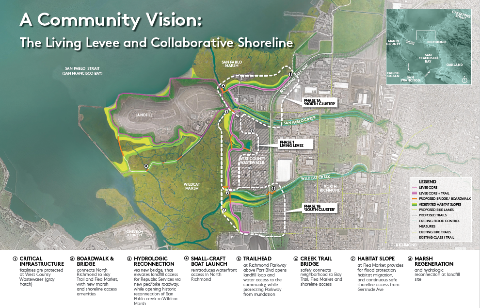
The North Richmond Horizontal Levee Project achieved significant milestones in advancing climate resilience, habitat restoration, and community engagement along the East Bay shoreline. Led by West County Wastewater with support from the San Francisco Bay Restoration Authority (SFBRA), this project combines flood protection, habitat restoration, and community input through a nature-based “living levee” design.
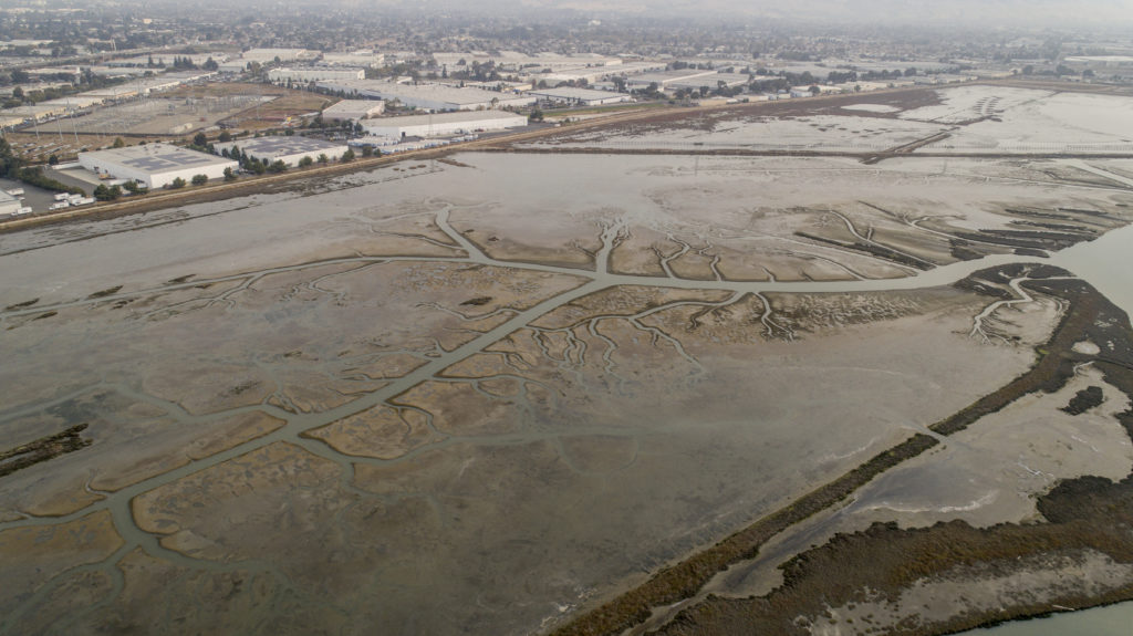
As part of the South Bay Salt Pond Restoration Project, Eden Landing Phase II intends to restore over 1,300 acres of former salt ponds to tidal marsh and enhance over 700 acres of managed ponds in Alameda County. The project includes restoring tidal marsh, managed wetlands, ecotones, 4.5 new miles of Bay Trail, and monitoring, emphasizing community engagement and flood protection. Building on nearly $7m in existing grants, $1.15 million awarded by SFBRA in 2024, a main feature of the project is construction of habitat zones that would provide gradual transitions from tidal marshes to upland habitats.
The Palo Alto Horizontal Levee Pilot Project is a pioneering nature-based infrastructure initiative designed to address sea level rise, enhance habitat, and improve water quality. Located next to the City’s Regional Water Quality Control Plant, the project features a horizontal levee that filters treated wastewater, provides flood protection, and supports the migration of tidal marsh habitats inland as sea levels rise.
Defining terms for nature-based solutions
Ecotone levee: gentle slopes or ramps placed bayward of flood risk management levees and landward of a tidal marsh. When properly vegetated, they can provide a wetland-upland transition zone habitat, attenuate waves, provide high-tide refuge for marsh wildlife, and allow room for marshes to migrate upslope with sea level rise. (Adaptation Atlas) Living levee: a term used to describe a form of ecotone levee that provides a transitional habitat on a gentle, ecologically diverse slope.
BCDC Regulatory Improvements
The BRRIT enhances the permitting process for multi-benefit habitat restoration projects, as well as flood management and public access infrastructure in the San Francisco Bay and along the shoreline of the nine Bay Area counties. Since its inception, 32 projects have been brought to the BRRIT, and 10 have been fully permitted.
In 2024, BCDC completed a year-long evaluation of its permitting program, identifying projects to improve the program systematically over the next several years. The first priority BCDC is addressing among those that emerged is the roll-out of an improved pre-application process, which will help applicants better understand permitting pathways and receive faster decisions.
Published by the San Francisco Estuary Partnership and Environmental Science Associates, this white paper sheds light on the permitting challenges associated with nature-based solutions and horizontal levee projects, identifying potential regulatory and permitting pathways and making recommendations for improvements.
The California Assembly Select Committee on Permitting Reform, chaired by Assemblymember Buffy Wicks, published a new report outlining best practices for permitting housing, electricity, water, and transportation projects.
Encouraging Collaboration Among People Doing Projects in the Same Places
OneShoreline, San Mateo County’s regional sea level rise agency, is redefining how communities prepare for climate change by uniting cities, agencies, and residents around bold, collaborative action. From building multi-benefit flood protection projects to guiding future development with resilience in mind, OneShoreline is weaving together public safety, ecological restoration, and inclusive planning in one strategy.
Seven regional and state agencies entered into an MOU committing to work together to address the growing threats of flooding and sea level rise in the Bay Area. By coordinating their respective roles and authorities, the partner agencies plan to accelerate implementation of adaptation projects, increase the region’s ability to compete for grants, and support partnerships to advance multi-benefit projects at scale.
A model of multi-agency collaboration, the Highway 37 Sea Level Rise Project unites Caltrans, the Metropolitan Transportation Commission, and four counties—Marin, Sonoma, Napa, and Solano—to plan climate-resilience upgrades for this flood-prone corridor. The effort integrates wetland restoration, transportation resilience, and social equity, aligning ecological and economic goals through a collaborative approach. In addition, a new partnership among state transportation and resource agencies has spurred positive discussions and actions that continue to move these integrated goals forward.
The Oakland Alameda Adaptation Committee is a coalition of over 30 stakeholders, including community-based organizations, Tribal liaisons, staff from the Port of Oakland and the cities of Alameda, Oakland, and San Leandro, and various agency representatives. The OAAC is setting a precedent for climate adaptation planning that is inclusive and science-based, addressing both environmental and social equity concerns in the Oakland-Alameda region.
doxycycline uti
doxycycline uti
fluconazole 200 mg tablet
fluconazole 200 mg tablet
diflucan 150 mg over the counter
diflucan 150 mg over the counter
doryx price
doryx price
fluconazole 150
fluconazole 150
amoxicillin clavulanic acid
amoxicillin clavulanic acid